Category Archives: Uncategorized

Skyrunning Mount St. Helens in a Day

The short version is that this is one of the more difficult trails I’ve run/hiked. But it’s also one of the more unique and spectacular.

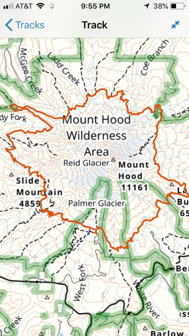
Syd and I ran the Loowit Trail #216 in a day; this is the 30-plus-mile trail that circumnavigates Mount St. Helens, an active volcano that exploded on May 18, 1980. I’ve been to the top a dozen times and wanted to experience the mountain from a different perspective.

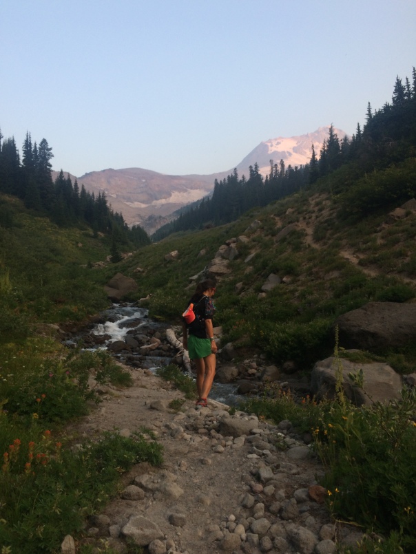
We set off at 7 am on August 16 from the June Lake trailhead and traveled clockwise.  It was foggy—typical of the volcano—and cool. Heading westward, we meandered through the woods where the huckleberries that lined the trail soaked our feet with dew. We soon entered a giant lava field of gigantic basalt boulders, the trail marked quite well with 8-foot-high poles and cairns; a few times we paused to scan the fog for the next trail marker or quickly consult the map (We both use GAIA phone app). This was neither running nor hiking but rather boulder hopping, over jagged and sharp chunks of basalt.

In an hour we reached the blast zone, a spectacular area that from afar looked like alpine meadows, the sand and lava were covered with moss and wildflowers and sparsely dotted with alpine fir. We passed a lava heap of Butte Camp Dome and then descended into the headwaters of Coldspring Creek, a dry drainage of sand and lava. To get in and then out of the dry creek bed, we handlined down 50-foot ropes that had been placed by past hikers or rangers.

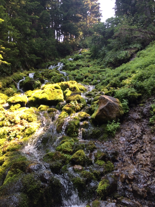
Another hour and 2000 feet uphill later, atop Crescent Ridge, we could see into the vast greenery of the Toutle River drainage. We descended 1000 feet through thick head-high huckleberry fields—the last lush green we would see that day— to the creek, at mile 13, our first water source. To get into and back out of the Toutle Creek bottom, we used another set of ropes as handlines.

Then, we zigzagged another 1000 feet up a wide-open sand moraine to the vast pumice plain of the north side, where we spent most of the afternoon, on the undulating trail, which stayed roughly at 4000-foot contour for 10 miles. The wildflowers of lupine and paintbrush were abloom, and we spied the occasional chipmunk, the crags of the Mount Margaret backcountry, and Spirit Lake. No trees: just remnant weathered stumps from the blast of four decades ago.

Here the trail was mostly sand, fairly well-marked by the trail tread, poles and large cairns. There was absolutely no shade whatsoever for the rest of the day. The temp was around 70, with a light breeze and occasional scattered clouds: perfect running weather. Here, unlike the south and west side of basalt and andesite lava, the surface was pumice: handheld sizes of round, lightweight, light-colored, sandpapery stones that crunched when we ran over them. Occasionally, we ran through patches of grasses in varied shades from tan to green. The crossing of the north pumice plane took several hours. We found a spring at mile 19 (it’s labeled on the USGS topo map) about 500 feet off trail, uphill, in a thicket. Soon thereafter, we crossed at least three more streams and one other spring. Since the northeast corner of the mountain is accessible from Windy Ridge visitor’s area, we saw a few day hikers and backpackers.

To exit the north pumice plain, we climbed another 2000 feet in a narrow, steep canyon to Windy Pass. This included a one-mile detour to the viewpoint at Loowit Falls—a 100-foot waterfall that comes out of the crater at Sasquatch Steps, a series of basalt cliffs. Still, no trees, no shade. And more pumice, now scattered with basalt boulders.

From Windy Pass, with a view of Mount Adams, we descended to Plains of Abraham, the east side pumice field by 4 p.m. I was nearly out of food, having consumed around 2000 calories, variations of compacted dried fruit, nuts, and oats plus one peanut butter-honey-banana sandwich. From here, I had mistakenly thought we had an 8-mile descent to the car. In reality, we had 10 miles. And it wasn’t a descent. We dropped down to the northwest side overlooking Ape Canyon and Muddy River drainage, and then traversed the south side back to June Lake. But the traverse was interrupted by giant chasms—dry streambeds of lava tubes and loose lava  and loose sand—that were 100 feet deep. For Muddy Creek, we descended a steep sandy rocky slope to the bottom and then climbed back out. Then we repeated that four or five times, the chasms separated by alpine tundra of foliage and wildflowers. We stopped for water and to empty sand from our shoes where Shoestring Glacier gave us a small trickle of meltwater. Nearing the June Lake Trail, we traversed the Worm Flows lava field, more boulder bounding, ending like we began. The June Lake trail gave us the first shade since the Toutle River descent. We made it to the car in the beautiful mountain twilight.

Stats

34 miles, 10:40 moving time, 12:20 total time, 7500 feet gained, 7500 feet lost

Water, from June Lake clockwise

Mile 11, Toutle River

Mile 19, spring

Miles 19 to 21, multiple creeks and one spring

Mile 28, Shoestring Glacier drainage

Gear

Solomon running vest, 12 liters with two 500-liter soft flasks

Patagonia Comfort Tropic Hoody, Patagonia Nine Trails Shorts, Lululemon shirt, Smartwool socks, ball cap, Smith sunglasses, Inov8 Trailroc shoes

Extra layers I didn’t use: Nike running pants, Outdoor Research Helium II jacket, buff, Arcteryx hat (Syd carried lightweight gloves which I wish I’d thrown in my pack)

2000 calories

Biolite Headlamp, Dermatone sunscreen, iPhone w GAIA app, Goal Zero phone charger

Syd carried a small Katadyn filter bottle we used to filter stream water.

Cold Edge: Ski + Sail Svalbard

Aboard the Aleiga, Ski + Sail Svalbard, May 10-20, 2019

Day 1-2, Longyearbyen
It is a long haul to Svalbard, a place the Vikings dubbed “Cold Edge,” a tiny Norwegian archipelago between 74 and 81 degrees north. After 24 hours of travel, we fly in on beautiful sunny day: the landscape is covered in snow and fjords are blue with water and white with ice. It looks monochromatic—which I’ll later find is not the case. Longyearbyen is a coal mining and tourist town of 2500 permanent residents with a small university outpost and a few shops with an excellent selection of high-end outdoor gear and gun rentals. If you leave town, it’s mandatory to carry a rifle for polar bears. At the grocery, we show our boarding pass to buy beer, rationed because it’s tax free. At this time of year, it’s daylight for 24 hours. We see locals run and ski and bike: we later learn it’s because today is a less-common sunny windless day with temps above freezing. Snowmobiles litter the landscape like kids’ toys left in the yard. Stray reindeer nibble the tundra: they look like a cross between an elk and cow, but the size of a Shetland pony. The buildings are classic Scandinavia: outside nondescript and simple almost like pole barns with windows built on stilts because of permafrost; inside suddenly beautiful wood floors, knotty pine ceilings, stylish furniture, crispy clean. And the indoors are roasting warm. At the museum, we leave boots at the door and wear loaner slippers. At the restaurants, we eat moose burgers, fish burgers, fish stew.
Day 3 Longyearbyen to St. Johnsfjorden
We meet Christian Cesa, our jovial Italian mountain guide. He is a bit concerned about space because we have six skiers plus him and the skipper Delphine in the Ovni 455—a 45-foot aluminum-hull sailboat named Aleiga, meaning “All In.” The boat has 8 berths, two toilets, a small dinghy and lots of electronics. In addition to skis and a ski backpack, we each have a small duffel. I have spare ski clothes, comfy boat clothes, 7 beers (one per night), two pints of Oregon whiskey, indoor shoes, a camera, my new Kindle, and 3 packs of wet wipes (no showers on the boat).
At 4 pm we meet the boat at the harbor in Longyearbyen. The weather overcast and blustery with whitecaps and cold and sea dampness. The boat is stocked with a week of provisions including 550 liters of water. Our skipper Delphine is a smiley good-natured French woman living in Norway. After a safety briefing, she makes the difficult upwind exit from the harbor with expertise. We motor-sail out Adventforden (forden = fjord), and into the huge open water of Isforden. Jill and Eric rig the jib sail: we make 10 knots downwind. Since conditions are good, Delphine decides to pass the planned anchorage, and continue up Forlandsunde (sound) into St. Johnsfjorden at the foot of the Gaffelbreen (breen = glacier). She finally anchors at 4 am, 10 hours later.
Day 4 St Johnsfjorden to Lillehookfjorden
In the morning, I make coffee and scramble above deck. We are in a bay surrounded by mountains which are covered in ice and snow and spackled with rocks and tundra. After breakfast of muslie, yoghurt, cheese and bread, we assemble to ski: don clothing, pull on climbing harness, load our packs, crowbar feet into ski boots, unstrap the ski bags from the deck (no easy task on the slippery deck wearing ski boots), put on life vests. Before loading into the dinghy, we have a polar bear safety briefing. Our weaponry includes: a small handheld flare, a flare gun with three cartridges, and two 30.06 rifles. The flares are not to signal for help, but to point at the bear. Eric and I climb in the dingy with Christian, the arsenal, seven pairs of skis, and Delphine at the outboard motor. Ice chunks float in the water like melting cubes in a punch bowl. Delphine noses the dingy to an ice shelf three feet above the water and presses the dingy bow against the ice by revving the motor while we clamber out and haul the skis to the ice.
When the rest of the crew arrives at the ice shelf, we skin up the ice onto the Gallelbreen. But the weather is stormy and wet: poor visibility, 2 degrees C, and light snow. About an hour into our ski up the low angle glacier, conditions deteriorate. Had we been in the Alps with towns and rescue nearby, says Christian, we would keep going. But, considering the remoteness, we rip skins and ski back to the ice shelf where the glacier meets the sea. No is low tide, so we step from the ice to the exposed rocky shore.
Once back to the boat we lunch on reindeer stew with lingonberry jam and rice. Then set off motoring to the next anchorage. At one point, the snow comes down so hard and thick is creates a layer of broken snow patches on the water. We sail well into the next day.
Day 5 Lillihookfjorden to Ny-Ålesund
Time is measured by breakfast, ski, lunch, motor to new location, light dinner. After our last meal of the day it seems like 9 pm perpetually, because it’s late in the day but with the constant light doesn’t ever seem quite like bedtime. Today Eric and I wake up in our bunks at 2 am from the sea ice hitting the aluminum hull of our boat like an ice machine. I wake again at 3 am to the sound of the anchor dropping—Delphine anchors us in a fjord at the bottom of glacier with sea birds all around. We are tucked into Signehamme (hamme = bay) where Lillehoodbreen (glacier) meets Lillehookfjorden (fjord). We see two other boats anchored among the floating chunks of sea ice—more skiers. I’m fully up by 7 am drinking coffee on the boat while tiny sleet pellets ping the vinyl deck cover. We spy ptarmigans, seals, and an Arctic fox. More ice litters in the sea like gravel strewn on a driveway. Gray clouds hang above the mountains.
Again: don ski gear, ride the dingy to shore, and climb from the dingy onto an ice shelf. We climb Dronning Maud peak 866 meters: with intermittent fog we barely see the bay where our boat is anchored, but still make the summit. On the ski down, we find soft powder over granular ice, and then slushy powder over granular ice: a university student Eric and I met in Longyearbyen told us this granular ice is called “Svalbard Sandpaper.” After lunch of baked salmon and pesto pasta, we motor to within a hundred meters of the Lilliehookbreen: a massive wall of seracs that stretched a mile across the bay; the sea of ice chunks tinkle against the aluminum hull as we drift and stare.
Day 6 Ny-Ålesund
In stormy conditions, Delphine expertly brought Aleiga to dock late the last night to Ny-Alesund, small research outpost, the most northern settlement in the world with permanent residents. I wake up abruptly when another sailboat of skiers pulls into the tiny harbor and slams into Aleiga. Only minor damage. Stormy, no skiing: low clouds, fog, wind, snow, cold. In the research outpost of 50 buildings occupied by a dozen nations and 50 permanent residents, a 1-kilometer gravel road loops through town. This road is the only place visitors are allowed without a rifle. We learn there’s no locks on the doors for polar bear safety. This place started as coal mine, then became a base for whaling, fur harvesting, polar exploration, and now research on all things Arctic like ecotoxins and climate change. We visit a self-guided museum that’s always open (no lock) and a small tourist shop (bought hats, chocolate, and other sundries). We meet two friends of Delphine and grill them with typical tourist questions about their life at Ny-Alesund. We mention we are low on wine and later the friends bring us two boxes and a bottle—generosity in this place where supplies of everything are likely short.
We are stuck all day—too stormy to ski and too stormy to sail—and pass time by walking the town loop. I get restless so I put on winter gear and run 10 laps around the 1k loop. We hope we’re not stuck her too long. Baked halibut for dinner.
Day 7 Ny-Alesund to St. Johnsfjorden
After two nights in Ny-Alesund we head south at 5 am in slightly lighter wind and steel gray overcast. The sea is rough, so everyone feels crappy in various stages of sea sickness. Intermittent napping during the day helps. Delphine and Christian look at two ski spots on the way back down the Fordlandsunde but the Aleiga is limited by seas too rough to anchor. We are anxious get off the boat and ski. We see lots of reindeer on shore. Finally, 10 hours after sailing we arrive back into St Johnsfjorden. This time, Delphine pulls the Aleiga directly alongside an ice shelf, which extends at least a half mile from the glacier seracs to the dark sea. “How thick is this ice?” I wonder when I jump off the boat. Christian places three ice screws to tie up the boat, and then we drag the anchor nearly the entire length of the 50-meter chain up onto the ice as a safety. Eric and I unload skis, being instructed to deposit them five meters apart to distribute skier weight on the ice shelf. I silently run through the procedure if someone falls through the ice into the water. We skin across the ice and up a peak called Lowzowfejella, 642 meters. At the top I connect with a cell tower and try to send a text to my girlfriend Syd. No luck—we are far from everything, incommunicado by today’s standards but have coms: a marine radio, two sat phones, Eric’s satellite Garmin In-Reach. At the top, the ski down is variable: wind crust mostly, but I follow Eric down a gully where we find soft snow. After dinner of cabbage soup, Christian and I drag the anchor back to the boat, remove the ice screws, and jump on Aleiga where the two sailors of our group, Jill and Eric, are always crewing for Delphine. She anchors a few meters away.
Day 8 St. Johns Fjord to Trygghamma
I wake early to the noise of the anchor coming up and diesel motor starting. Eric and I have a bunk room, which is has enough floor space for two ski packs and one person to stand—we get changed for skiing one at a time and keep our duffel bags on our bunks. The first few days, I notice the stench of sweaty ski clothes, but now I don’t really notice any smell. Delphine is at the helm photographing two seals on the ice; she puts the Aleiga within five meters of the seals. Then we head south, to a walrus colony on Poolelepynten, a point on that has an old trapper’s cabin. Seals, a fox, many walrus and a minke whale, but no polar bears. The day’s sail takes several hours; we have a bit of warm wind so Eric and Jill put the stay sail up. The sea is much calmer and the temperature much warmer. Getting closer to civilization, we get cell reception, sail past the Russian settlement of Barentsburg, and head into Gronfjorden. We anchor at the Aldegondbreen and take the dinghy to shore, a rocky coastline on the edge of the glacier. We ski up an unnamed peak at 669 m between Strandlnulen and Qvidstadfjellet peaks. The ski down starts as firm windblown then as we tuck into a gully, becomes dry dense wind-packed powder—six inches of soft, untracked that is fabulous. We exit to glacier, load onto the Aleiga, and sail to Trygghamma (hamma = bay) for our ski objective tomorrow. Dinner: rice and salmon.

Day 9 Trygghamma to Longyearbyen
When I wake, I noticed something odd—the boat is not rocking. The water in Trygghamma is glassy with high overcast and warm temps. By warm I mean just above freezing with no wind chill so for the first morning of the trip I wear my light puffy instead of my thick down one. We don ski gear and take the dingy to Protektorbreen and skied up Daudmannen, a 770-meter peak. On the peak, we see many ski tracks. Fog lifts and we have enough visibility to ski supportable smooth firm crust and then traverse to the top of Daudmannenbreen, a steep glacier with a collection of seracs and an ice wall. Christian pulls out a rope, and anchors it on the tail of his ski jammed into the snow, so we can slide onto the glacier using a hand line. We exit by skiing down a drainage runnel that’s 3 meters deep. Back at the boat, we lunch on mutton stew and sail to Longyearbyen harbor. En route, half of us take hot showers, (the first of the week) in the tiny bathroom with a scant two liters of water. At Longyearbyen, we moor, take on 285 liters of diesel, and fill up the water tanks. Patty gives Christian and Delphine each a pair of sunglasses. We walk to town for dinner and a tour of a few bars with Delphine and Christian.
Day 10 Longyearbyen
We pack up for the trek home. We spend the day in town before heading to the airport at midnight. I want to run to the seed bank so I set off. But I don’t want to go past the sign demarking the edge of town, the point where I need a gun. I go past the town coal-fired power plant, a kennel with 50 sled dogs and a snowmobile shop. I run all the paved roads in Svalbard: it takes an hour. We walk through town again and again to pass the time in the perpetual daylight before we begin what is at least 24 hours of travel to get home. In a few hours when we land in Oslo, I’ll be shocked by how green the land looks—adjusting from the many shades of white snow and many shades of blue sky and blue sea. Just before leaving our small guesthouse at midnight to catch our flight, I see Wendy and Chris walk into the shower with their skis, to wash off the saltwater and the last remnants of Svalbard Sandpaper.

Spring SkiMo Kit: light, compact, safe

What’s in my spring skimo pack?

I’m in the mountains frequently. I work at Mount Hood Meadows Winter Resort, volunteer with Crag Rats Mountain Rescue (Hood River, OR), and work part time as an international expedition leader.  I love being in the mountains and also like having a good margin of safety—all seasons. I like to travel light, but also plan for contingency. I have a number of backpacks. A fully loaded mountain rescue “ready pack” hangs in my mudroom. I have a tiny 10-liter mountain running pack for summer. But my favorite, is my ski mountaineering pack, or skimo for short. Almost year-round, my ski pack is in a perpetual state of being packed, or strewn about my mudroom drying. I take almost the same gear, every trip in the mountains. Partly because I’ve figured out a system that works for me and partly so I don’t have to think too hard when packing. So, for recreational outings, here’s my skimo kit for the upcoming spring and summer skimo season. Keep in mind this kit is generally for fair weather, one-day climbs of the Cascade volcanoes. You’ll notice there’s three things I bring a backup of: headlamp, gloves, and puffy.

Key: • Always. o Optional


Clothing
I’m a huge fan of the influx of European brands to the global outdoor scene. High tech fabrics are constructed into well-fitting garments with minimal accessories. Function, style, and light-weight often come with a higher price tag, but cost is amortized if you keep gear for a long duration. I am not sponsored by any companies, but put in a few brands for examples.
Bottoms
• Synthetic boxers (ExOfficio)
• Synthetic long underwear (Patagonia)
• Soft shell pants (Mammut Base Jump or Tetramar)
o Waterproof shell pant with full side zips (Mammut Preclip)

Tops
• Synthetic or wool long-sleeve zip-t (Trew or Smartwool) or thin hooded long-sleeve sunshirt (Black Diamond)
• Lightweight fleece, full zip with a hood (Eider)
• Thin uninsulated softshell windshirt (Outdoor Research Ferossi jacket is one of my favorite pieces of all time).
• Waterproof Gore-tex jacket (Mammut Nordwand)
• Synthetic puffy, sized big enough to fit over all my clothes including hard shell (Rab Xenon Hoody with Primaloft insulation)
o Down Puffy for backup, really cold alpine starts or as an emergency layer

Accessories
• Buff/neck gaiter
• Fleece hat
• Medium weight wool-synthetic socks (DarnTough)
• Helmet (CAMP Speed)
• Goggles with storm lenses (Smith IOS)
• Sunglasses with yellow and dark lenses (Oakley)
• Lightweight gloves (Smartwool Spring)
• Backup gloves (Outdoor Research)
o storm mittens (Black Diamond)
\

Ski Gear
Sure you can make many different tools work: snowshoes, telemark skis, or a splitboard. But alpine touring gear is the most versatile.
• Skis with tech bindings with skins and poles. I use the one-ski-quiver Dynastar Mythic 97 for most of winter. For summer, I use a lighter Black Diamond Carbon Ascent with 90 mm underfoot in shorter length. I used nylon-mohair skins because they are lighter and glide better (Black Diamond Glidelite) I use Dynafit tech binders on all my skis.
• Alpine touring ski boots: light enough to spend all day but no so light that my feet get cold or I have difficulty driving the ski on a technical descent (La Sportiva Spectre 2.0 with Intuition ProTour liners)
o Self-arrest grip pole (Black Diamond Wippet)
o Ski crampons—on low-angle firm snow, this is an excellent ascent tool (Dynafit)

Avalanche Gear
In winter I use an airbag pack: this year I used the Black Diamond Jetforce Tour 26. But in spring and summer, when conditions are stable and I need to carry more gear, I like the larger mountaineering-style pack, the CAMP M3. I always carry a beacon, shovel and probe too.
Glacier Travel
For nontechnical volcano climbs, I like going light. But, be advised that the light aluminum and carbon skimo gear isn’t that great for ice and mixed climbing. For that you’ll need something burlier.
• Aluminum ice ax (Black Diamond Raven Pro)
• Aluminum full-frame crampons (Black Diamond Neve)
• Ski mountaineering harness (Black Diamond Couloir)
• Basic crevasse rescue kit: set of prussics, a sling, three locking carabiners, 5-meter webbing, cordlette, pully, micro8, and a 30-meter-long 8-mm glacier-travel rope.
o Picket. Since I’m bringing skis, I usually don’t bring a picket.
o Ice screw. If I’m skiing, I rarely need an ice screw.
Miscellaneous
• skin wax
• chemical hand warmers
• sunscreen + lip balm
• Headlamp + extra batteries
• Backup headlamp
• cell phone with GPS app (GAIA)
• Map and compass (by way of cell phone)
• A small repair/survival/medical kit: wire, steel wool, a binding screw, cord, zip ties, electrical tape, and a small binding tool. For longer trips, I sometimes add epoxy and hose clamps to repair binders, at least two polyurethane ski straps, wind- and waterproof matches/lighter, medical and/or paper tape.
• Food and water
o Bivy sack

Hood 360: Skyrunning the Timberline Trail in a Day

I was really worried about—in order of highest risk—falls, fording the streams, and not finishing by dark. I wasn’t really worried about water: I knew we’d find tons of creeks and springs to provide water on the 41-mile Timberline Trail which circumnavigates Mount Hood. I wasn’t worried about food: I knew from other epic adventures that a) any food would taste bad and be nauseating, b) I’d have no appetite, c) I would have to force myself to choke down any sustenance.

IMG_8075
My motivation was multifocal for running the gargantuan 10,000-foot up/down trail in a day. I wanted to test myself with the feat of endurance on this classic trail. I wanted to complete the trifecta of circumnavigations: I’d ridden the 100-mile bike ride around the peak and I’ve done the ski circumnavigation, both in a day. But I also was looking for a deeper understanding of Mount Hood, by connecting all the sections of trails that I’d been on for mountain rescue missions. My unit, Crag Rats, is the mountain rescue team that covers the north side of the mountain (cragrats.org).


So this one-day trail run percolated for a many years in my brain until I realized with a low snowpack and relatively decent running fitness, this was a good year. Realistically I only have a half-dozen friends who a) run longish distances and b) are wont to dig deep into the pain cave. Megan said yes, about 30 seconds after I texted her.

I brought the following in a 10 liter Mountain Hardware backpack: 3 liter water bladder, 1 food bottle with Vitargo and Gatoraid, an Outdoor Research Ferossi jacket, an extra pair of socks (absolutely vital), my iPhone with Gaia GPS app, a Goal Zero battery for my phone, a Steripen UV light water purifier, 6 chlorine dioxide tablets, a tin of Dermatone sunscreen, a roll of tape, Band-aids, and 2000 calories of food, with variety being key (peanut butter/honey sandwich, roasted potatoes which were the bomb, six Hammer gel packs, two Honey Singer Chews packs, a half dozen fig newtons, dried chewy bananas and a couple Mojo bars. I wore a hat, sunglasses, buff, long sleeve Patagonia silkweight shirt, Patagonia ultramarathon shorts, Under Armor tights, Smartwool socks, Outdoor Research gators, and Hoka One One Challenger 2 trail shoes.


We set off from Timberline Lodge at 5:07 a.m. on August 9 at dark and headed counterclockwise. Although one can consider multiple starting points (Cloud Cap and Ramona Falls) and either directions, we chose this route for a variety of reasons, mostly for simplicity of starting and ending at Timberline and splitting up the two major climbs.
At dawn we ran down into White River, and through Mount Hood Meadows Ski Resort, which was replete with bubbling creeks and beautiful wildflowers. We crossed Clark Creek, climbed up Pea Gravel Ridge, descended into Newton Creek Canyon, and climbed to Gnarl Ridge. From there, we had a long steady climb into the alpine to the highpoint of 7,300 feet. We were greeted with spectacular views of the rarely seen east face of the mountain. Once we hit Cooper Spur, we descended to Cloud Cap Saddle. Status: 15 miles, 4 hours, 9 a.m. On schedule.

IMG_8130
We the dropped into the Eliot Creek, crossed the boulder bridge after a quick fifth-class climbing move and set off on 20 miles of spectacular. Bubbling creeks, wildflowers, springs percolating from the greenery, mossy boulders, and a mostly-smooth wide trail, that was partly shady. We didn’t know it at the time, but our pace slowed significantly due to fatigue and trail conditions. We crossed multiple streams including Coe Branch to end up in Elk Cove, which was absolutely spectacular with wildflowers, glacial brooks, and a large marmot. We took the first of our two five-minute breaks during the 14-hour day: we changed into dry socks after Megan slipped and dunked her foot in a creek. But the black flies were biting so after a quick change we were off again in five minutes.
Running through Cairn Basin, we descended the long, shaded run which turned out to be a bit painful, considering the trail had lots of roots and our legs were shot. Downhill was difficult. On the ridge at the Muddy Fork, the giant rhododendrons showed up, which are typical of the west and south side of the mountain. I was a bit worried about he Muddy Fork and Sandy Rivers: both were swollen with the afternoon heat. But both had log bridges and were easily passible.


By 2 p.m we hit Ramona Falls: picturesque, shaded, and serene. We were exhausted. We sat down for the second time for a solid 5 minutes. But: we still had 10 miles and 3000 feet of elevation to exit. It was, in a word, painful. We walked, but only bit faster than the overnight backpackers. In 5 hours, we stopped twice for water and nothing else. We said a total of about two paragraphs to each other. Although it was painful, it was actually quite beautiful too: we climbed and crossed the gargantuan sandy Zig Zag Canyon and the tiny sandy Sand Canyon.
We arrived, 13 hours and 58 minutes later at Timberline Lodge, a few hours before dark. No, we were not able to stomach a burger and a beer. We were able to change into clean clothes and drink chocolate milk. We had 3.5 falls (me: one). No injuries. No dehydration or heat illness. No rhabdomyolysis, which crossed my mind more than once since two days prior our mountain rescue team was called out for the same.
Much has been said about recovery for this sort of nonsense. I stretched. I slept nine hours. I kitesurfed and I got on my bike for a few light recovery rides in the days following.

IMG_8163
My advice:
If you don’t already have this in your list, then don’t do it.
No: we didn’t stop to enjoy the wild flowers but rather saw them in an endorphin-fuled, kaleidoscopic blur.
Yes, we went deep, very deep, into the pain cave.
Yes, we had fun: type 1 for 30 miles and type 2 for the last 10.
No it wasn’t the hardest 24 hours of my life: that was climbing Mount Rainier in a day. But this was close.
Yes there are other circumnavigations: Three Sisters (48 miles), St. Helens (30 miles) and the granddaddy the 93-mile Wonderland around Mount Rainier.
Yes: this is a once in a lifetime. Please don’t ping me if you want me to join you. Well, on second thought, I’ll see how I feel tomorrow.

SkiMo in the Bernese Oberland, April 2018

In 2012, I wanted to ski the Haute Route, the fame ski mountaineering tour from Chamonix, France, to Zermatt, Switzerland. I couldn’t get any of my friends to go, because it’s not the sort of trip too many people understand. I found a guide, signed up, and went with 9 other people I didn’t know. I met a guy on the trip named Michael, a Portlander who had the same story: job, family, great skier, and network of friends who also couldn’t go. A couple from Bend, Gillian and Jan, were on the trip. Our guides were Pete Keane (timberlinemtguides.com) and John Race (mountainschool.com). We had a spectacular tour. Michael and I stayed in touch but rarely saw each other except for a one-day ski-circumnavigation of Mount Hood. Another awesome trip, btw. In 2014, we got geared up for round two and hired Pete and John for a tour of the Ortler Circuit in Northern Italy: nicer huts, more skiing. Jan and Gillian caught wind of it jumped in and we filled the trip with friends in a couple weeks. Another fabulous trip of sun and powder. Not wanting to give up the good run, in 2016, we booked a 9-day backcountry tour of Hokkaido, Japan, with Hokkaido Powder Guides. This time, we filled the trip in two days! All I can say about skiing in Japan: go now.  It is unbelievably the best powder on the planet. So when planning for 2018 rolled around, Michael and sat down over beers on my kitchen table, we picked one of the burliest and most famous ski tours of all: the Bernese Oberland in Switzerland’s Jungfrau Alps. We dropped and added a few friends and booked Pete and this time John’s wife Oliva Race. Here’s the short (or maybe verbose) version of our ski mountaineering tour in the Bernese Oberland.

1-02
Day 1, Interlaken to Kleine Scheidegg. Our group trickled in over a few days, some waiting for the airline to deliver skis. I had carried on my full mountaineering pack and boots (yes I was that guy with two big carryons). I met up with Ben from Park City, we caught a train to Grindelwald, met up with David from White Salmon, and continued up to Kleine Scheidegg. The trains in the Jungfrau circuit are fabulous: run on time, your ski pass includes all train fairs, and they are all set up on a 25-minute run with 5 minutes in station, so you walk off one train on to the next. They are electric and have cogs for the steep valleys of the Jungfrau region. We went for a small ski tour in the closed part of the ski resort, made some chairlift laps in the spring corn snow, and saw the famed Eiger and Kleine Scheidegg hotel. We skied on a ribbon of snow through cow pastures all the way down to Grindelwald. It was a spectacular day, which is, as you will read below, a recurring theme.


Day 2, Interlaken to Piz Gloria. We got the whole 10 of us together including Michael, Gillian and Jan, me, David, Ben, Jill from White Salmon, Wendy and Chris from Seattle, and Eric from Hood River. We headed out for the Schilthorn ski area and the Piz Gloria, the famed rotating hotel where the first James Bond was filmed (and the second Kingsman film). Donning ski gear, we walked to the train station, caught a train to the famous Lauterbrunnen canyon and then jumped on a bus to Stechelberg. From there, the road ended at a tram station where we caught four trams, perfectly synched, to Gimmelwald, Murren, Birg, and ending at the Piz Gloria. We spent an hour looking at the views of the Eiger, Monch and Jungfrau peaks and touring the James Bond exhibit called 007 World—it was pretty neat with some movie memorabilia and crowded with non-skiing tourists. We skied a dozen chairlift laps in soft spring corn, had a few beers on the deck, gawked at the views, and took a “sky walk” on a walking platform about a quarter-mile long that was basically a two-foot-wide steel catwalk bolted to the side of a 100-foot cliff. We  made it back to Interlaken—three trams, one bus, one train—by 6 pm.
Oberlandmap2route

Our trip was counterclockwise: Day 3 red, Day 4 green, Day 5 blue, Day 6 yellow, Day 7 purple, Day 8 orange and off map.

Day 3 Interlaken to Hollandia Hut (3240m). After meeting up with Pete and Olivia and having a briefing and dinner the night before, we set out that morning. We again donned ski gear and our packs which we would live out of for 6 days. Most of us had our day ski touring gear, a ski mountaineering kit (ski crampons, boot crampons, ice axe, helmet, and harness), and a change of underwear, spare socks, a sleeping liner, and cotton t-shirt for the huts. The huts supply breakfast and dinner, and a bunk with a mattress, small pillow, and comforter. We walked in ski boots to the Interlaken train station, took three trains to Grindelwald, Kleine Scheidegg, and then through the Eiger to the Jungfraujoch, with a stop half way up to peer out the windows in the Eiger. The Jungfraujoch train station is at 11,333 feet elevation, essentially the top of Mount Hood. From the Jungfraujoch, this would be the last time we would see any hint of clouds. We skied down the Jungfrau Glacier a bit, and then put on skins to ascend a crevassed slope to a col above the Kranzberg Glacier. From there, we made a long ski descent on the Kranzberg, avoiding crevasses, to the Hollandia Hut. Snow was soft and creamy. When we arrived at the 100-person hut, we were the only group. As typical, the hut had bunkrooms, and was Swiss-clean and Swiss-orderly. Dinner that night was also typical, all eaten out of one bowl. Soup first, then cabbage salad, and then meat in brown gravy. Pudding for dessert. Bottled water cost around $12-15 for 1.5 liter; tea water and beer around $8/liter. The water from many of the huts is collected in cisterns from melting glaciers the year before; power comes from solar and/or diesel generator; supplies come from helicopter sling loads; toilets are a mix of self-composting the liquids and hauling out the solids. We could charge phones and had cell receptions at the first two huts.


Day 4, Hollandia Hut to Konkordia Hut (2850m). On day two, we skied up the Abeni Flue Glacier to the Abeni Flue peak. The snow was firm in the cool, clear morning but softened to perfect spring corn for our ski down at 10ish. We descended the AbeniFlue and Grosseraletsch glaciers to a ginormous flat meeting of several glaciers called Konkordia Platz above which was the Konkordia Hut. This is the famed hut with the stairs built into the rock cliff: 467 steps (the last two flights extended in 1980 due to receding glacier) for a 150-meter climb. Sure, it was a bit nerve-racking, especially every time I looked at the bolts holding the staircase to the rock. The routine at the huts is to pull of ski boots, get the foul-smelling liners, socks, and climbing skins in the sun to dry, find a bin in the boot room for sharps—ski crampons, boot crampons, ice axe—and getting water and a beer. This was one of the first huts I recall having beer on tap on the deck: keep in mind the kegs come from helicopters. This was a full hut of 100 people, and the barkeep were poured liters constantly. Some folks mix beer with Sprite or grapefruit juice. Some folks order rostie—a Swiss hut specialty consisting of hash browns, cheese, an egg or two, ham, bacon stirred up in a skillet and baked. Dinner: soup, no salad, chicken in a light favor-less curry sauce, pudding. This hut had a two-minute shower for $10!


Day 5, Konkordia Hut to Finsteraarhorn Hut (3048m). We left Konkordia Hut in boot crampons to get to the top of the stairs, descended the stairs back to Konkordiaplatz, and then put on skis with skins and ski crampons. We skied up the Grunegg Glacier to the apron of Grunegghorn, had a great ski down in barely soft snow—the snow softened every day starting at 10am and turned slushy around 1 or 2. We then skied uphill up to Grunhornlucke Col and down the other side to enter another huge glacial valley. After skiing down from the col, we were near the next hut, but kept skiing: back uphill to the apron of the Wyssnollen peak. We had another excellent ski down and then had a 30-minute crossing of the WalliserFiescher Glacier in the hot sun. We rolled into the Finsteraarhorn Hut at 4pm—it was a long day with over 5000-feet of climbing. At the hut, same routine: boots off, sharps in the bin (sort of like checking your weapons at the door), beer, and water. Then find a bunk, drop your gear, and hunt down more water and find time for a nap. This was a nice hut, clean and beautiful with knotty pine walls and ceilings, generator power, and bunks that were small cubbies instead of a row of bunks together. It was large and full, about 100 people. Someone mentioned it looked like Ikea. Gear management is key: we leave boots, socks and skins outside, sharps in the ski room, and everything else in the bunk: there’s gear everywhere from 100 skiers so you have to keep track of your stuff.  We’d spend 3 nights here. Dinner: broth soup, cabbage salad, pasta and brown gravy meat, pudding.

6-02
Day 6-7, Finsteraarhorn Hut
The next two days the crew toured from this hut after the typical breakfast. Breakfast was almost always: Instant coffee and/or tea, muslie and cornflakes with either yoghurt or milk (when mixed up was quite dry and bland), dense bread (quite dry and bland) with butter, jam, and some hard cheese (dry and bland). I lost weight due to the immense calorie burn of skiing, lack of protein and fat, and the dry, bland food. We did a long tour up the GrossesWannenhorn—this would be the only peak we would summit since most of the time we were skiing the aprons below the peaks. The top section was a narrow ridge that crossed over a low angle snowfield that ended in an ice cliff—a little dicey. The peak was a craggy rock that we scrambled to the top of. After a beautiful ski run about 3000 feet, we had to cross the flat part of the glacier again in the heat of the day: it was hot and took about an hour. Chris, Jan, Olivia and me took another short lap.  The second day the crew did a long tour up the apron of the Finsteraarhorn. Dinner at this hut was first broth soup, salad, polenta and sausage, canned pear half and the next night, broth soup, salad, and risotto.


Day 8, Exit at Bettmeralp. There was some consternation on how to exit the Bernese Oberland. Pete and Olivia did a lot of research and networking with other guides and the hut wardens. The exit they planned from the Finsteraarhorn Hut turned out to be somewhat melted—so we would have to walk up and down a cow pasture quite some distance and they were worried about the avalanche prone slopes in the afternoon with all the sun and solar heating. So, we backtracked a bit on a 14-mile, 6-hour exit which was shorter and safer. We had an early start with a 5 am breakfast, skied back up the Grunhornlucke, and skied back down to the Konkordia Platz—it was 7am so skiing down icy and firm and the snowpack was broken from many ski tracks leaving deep ruts from the previous afternoons’ slush. From there, we had a long ski—because the snow was so firm, we could glide straight down the immense Grosser Aletsch Glacier, the longest in the region. About two-thirds down the glacier, several miles, we negotiated a crevasse field and exited the glacier. We put on skins and climbed an hour up to a ridge where we traversed into a closed ski area and  across some large, recent wet avalanches. We skied across the ski area to the small, quaint, idyllic village of Bettmeralp: no cars, all snow-covered roads, maybe 3-dozen tiny Swiss cottages with snow-covered roofs. We skied right on the streets of the quiet village (the ski resort was closed for the season). We followed signs to a tram and took two trams down to the village of Fiesch. From there, typical Swiss fashion, we got the connecting train in 5 minutes and headed back to Interlaken. No one dared to remove ski boots for fear we’d be kicked off the train they smelled so bad. Once in Interlaken we had a short walk to the hotel where we had stored our gear: on the way back, the summer tourist took pictures of us as we walked through town—we must have looked odd, and smelled really bad. The hotel let us shower, and after food, some of us jumped a train to Zurich and others spent more time in Europe.
Two final notes:

First, our guides Pete Keane and Olivia Race were excellent. Low key, observant, safe pros. They had a good eye for good snow. Most of the Europeans left the huts at 5 or 6 a.m. and were skiing down before the snow softened. We had great timing every day because we left the huts later.

Second, don’t ask me where the next trip is for Michael and me, it’s already full.

Mount Hood SkiMo Kit

In my opinion, the most dangerous aspects of climbing Mount Hood, Oregon’s highest peak, are bad weather, bad snow condition (boilerplate ice or thick gooey slush), crowds, and a partner shy on skills. We had none of those December 14th 2017 After a week of high pressure, we had spring climbing conditions in December. My friend Dave Nunn, owner of Windance Boardshop in Hood River, and I set off for the summit. We skinned and ski-cramponed up Triangle Moraine, bootpacked to the top of Hogsback, and cramponed up the Old Chute. We left our skis at the bottom of Old Chute, so after we tagged the summit (no wind, clear skies, mid-40s temp) we skied down West Crater Rim and the ZigZag Glacier. Climbing time was three hours from the top of Palmer Chair. Here’s what I brought in my pack.
Skis.
My volcano skis are Black Diamond Carbon Aspect skis (166cm x 90mm). For winter, I use the Dynastar Cham 97 and Black Diamond Helio 105, but for skimo trips: light, short, narrow waist is lighter. I have the Aspects mounted with Dynafit Radical ST binders (second generation). Yea, Dynafit had tons of problems with these binders, but they seem to have the bugs worked out for the Radical ST 2.0 which I’m using on my winter skis.
Uphill.
I got Black Diamond Glidelite skins for all my skis this years: they are supple, more compact, and dry quicker. I use Dynafit ski crampons and the aluminum Black Diamond Neve boot crampons. I took a Black Diamond Whippet pole and an aluminum Black Diamond Raven Ultra Ice Axe—up and down the Old Chute was a two-tool climb.
Boots
I have about 100 days in La Sportiva Spectre 2.0 boots with aftermarket Intuition Pro-Tour MV liner, the only liner I’ve used for the past 10 years (I ski mold them, never cook). I love the way these ski: light but still stiff enough to drive a big ski in big terrain. It took a bit of fiddling to figure out the proper buckle tension. The plus is the generous walk mode. The biggest down side is the cuff lock froze in walk mode on a big tour in cold weather once in British Columbia.
Pack
This winter I’m skiing with the Pieps Jetforce 34 backpack: it’s is tall and narrow, so skis well. The ice axe holder and ski sling still allow airbag deployment. I like the top loading feature, so stuff doesn’t spill out all over the summit when I’m digging out food and water. I have a Ferrino Full Safe pack, which uses the Alp Ride canisters, but getting spare cartridges is no easy task because they have to be shipped to a dealer.
Other gear
Here’s a short list of everything else in my pack.
Small survival, repair, emergency kit.
Phone with Gia GPS app.
Camp Speed helmet, Smith goggles, Oakley sunglasses with yellow and gray lenses.
Two under-the-helmet hats, one buff, gloves (Smartwool liners, Smartwool Spring and puffy Black Diamond winter gloves)
Top: I almost always climb in a Patagonia lightweight base, Stio Gannet Peak lightweight fleece (fullzip, hoodie), and the Outdoor Research Ferossi wind jacket (fullzip, hoodie) I carried a Mammut Nordwand hard shell (for emergency), and Rab Xenon primaloft puffy (you guessed it: full zip, hoodie).
Bottom: I climb in ExOfficio boxers, Smartwool socks, Patagonia lightweight base, and Mammut Courmayeur soft shell pants. I carry a hardshell Marmot Precip full zip pants (for emergencies).
I brought a one quart ziplock full of food, and a 0.75 liter water bottle. Hint: I preload with water in the morning before hitting the mountain.


ICAR 2017 Soldeu, Andorra

I had the honor of attending the International Commission for Alpine Rescue meeting in Soldeu Andorra. I represented an eight-person delegation from the USA Mountain Rescue Association. In addition to our delegation, some 50 countries were represented in the 400-person meeting. The meeting was divided into four commissions: avalanche, terrestrial (high-angle rope rescue), aviation, and mountain emergency medicine. Here is a brief synopsis of what I felt was interesting.

Avalanche

Airbag backpack are proliferating. Carbon cartridges are the norm in Europe because they save weight, but these are not available in USA to gas import restrictions. Most US models will be available with refillable compressed air, via scuba tank, including those from Mammut, Arva, and Ortovox. There’s a trend for the balloon to wrap around the head/neck to possibly prevent trauma—but there’s no data yet to support this. The Pieps/Black Diamond Jet Force fan airbag deflates after burial to possibly create an airpocket—but again, no data. A new Aerosize airbag is a Polish company that comes in separate pack that can be used with any backpack.

Besides airbags, several teams including those from Wyoming USA and Switzerland focused on avalanche prevention with sponsors to produce blogs, posters, videos, and social media. Reference: backcountryzero.com from Teton County SAR.

Terrestrial

Italians with 7000 responders for alpine, canyon and cave rescues gave both a demonstration and a series of lectures that discussed simplicity. They keep gear universal so all 27 stations have exactly same gear. They follow ICAR recommends 3-stage autolock biners and 10 mm ropes. They do not use mechanical devices since the devices tend to have problems with frozen, wet, and dirty ropes. They showed two autolock knot alternatives to a prussic, called a bolognese and taz knots. For rappel/belay, they use the Kong Gigi for one person and the Kong Totem for heavier loads. Sometimes they use a W configuration with no breaking devices other than carabiners. They use flat single overhand bend to tie ropes together with a 40-60 cm tail which is easy to pass over the edge and through carabiners. ICAR recommends flat single overhand bend for low-tension and double fisherman for air or high tension to connect ropes. Many used Petzl direct connect, instead of Purcell prusiks.

Air

Lots of helicopter rescues in Europe with both hoist and long line. One exhibiting company showed a helicopter/airplane mounted cell phone detector. The Italians showed a hand-held model that detected buried cell phones in the Rigopiano Hotel avalanche. These detects cell phone pings, like a portable cell tower, but the victim phone must be on. The aircraft mounted version from Lifeseeker is not available yet in US.

Recco has a helicopter mounted long-range receiver, up to 200 meters or more. Not available yet in US. Barryvox has a long-range receiver antenna, which is already used in the US.

Medical

The medical commission discussed a variety of topics. Intermittent CPR guidelines need to be reviewed—the short version is that it’s ok to pause CPR for transport. A study suggested that on avalanche burials with multiple victims, it’s ok to do CPR for 5-7 minutes for initial victim extricated prior to searching for second victim: the conundrum is do you dig out everyon first, or do CPR on the first person you dig out? CPR prior to complete extrication from avalanche burial may help save time if patient supine or sitting—up to 4 minutes, but you’re doing CPR in a hole, which is difficult. Trauma likely higher percentage of avalanche fatalities than previously thought—possibly up to 30%. Selective spinal immobilization and clearing C-spine in the field—a big trend in the US—was not discussed. A talk reinforced that avalanche survival with complete burial, the only good outcome is bystander rescue with short burial and quick return of life. Fatalities directly correlate to duration of burial and air pocket, and if a professional rescue team is called in, it probably is too late.

Niseko and Tokachidake, Hokkaido, Japan

Japow, Niseko and Tokachidake, Hokkaido, Japan

Ten friends set off on a guided backcountry ski trip on the north island of Hokkaido, Japan; it was one of the most memorable 9 days I’ve ever had on skis. Each day by itself was perhaps the best powder skiing I’ve ever experienced. And we had 9 days.

The Summary

We went with Hokkaido Powder Guides, specializing in backcountry trips. In 9 days, we climbed 3 volcanos, skied 50,000 vertical feet of 5% untracked powder, and rode only two chair lifts. Travel from PDX was easier than going to Europe. The order of Japanese culture resembles the Swiss. The lodging was excellent, food strange and often delicious (mostly) and the bus transfers were exact.

Niseko

We spent the first five days skiing Niseko and staying at a family-run bed and breakfast called Ramina within walking distance of Hirafu ski village. For breakfast, we had a plates of salted marinated fish, baked gelatinous eggs, a tiny weirdly-tasting sausage, some sort of pickled meat, rice, miso soup, and green salad. The owner baked fresh bread and put out homemade jam, yogurt, and fruit.

Day one was bluebird sky, about 15degF, and 6 inches 5% snow on top of 12 inches from the day before. Our two Whistler, Canada, guides, Nicholas and Sam, met us at the lodge in the ubiquitous 4×4 Toyota vans. We stopped at 7-Eleven to pick up lunch (sweet rice rolled in seaweed, nuts, and chocolate bars). We skied Nimi Onsen among silver birch groves. The highest peak we climbed was 3,300 feet, which had views of the ocean. The snow was light, untracked, and knee-deep. This would be the theme for 8 more days.

Apre ski, we stopped at an onsen, a natural hot springs lodge, which would become a daily ritual. Men and women are segregated, except for one day we went to a mixed onsen. You pay, get a towel, grab a Sapporo beer from a coin-op vending machine, step into the locker room, strip, take a shower (which you do sitting down on a stool with a hand sprayer), and then step into the outside hot-spring-fed pool–naked. We dined at a small, but very popular restaurant that specialized in ramen noodle soup with a hearty rich broth, alongside tables of other skiers and snowboarders, many from Australia.

On Day 2, we woke to sun and cold temps and hiked Yotei, a volcano in the middle of the valley, about 6,000 feet elevation (our climb was 3,000 feet). After three-hour ascent, we skied down in ankle- to knee-deep powder in the silver birch trees. Apre ski we had the hot-tub onsen and sushi.

On Day 3, we drove an hour to Kiroro Ski World resort, road two lifts to the top, then skied out of bounds (after obtaining a permit and filling a route plan with ski patrol). We then made four long runs about 1500 vertical feet each in waist deep powder among silver birch. We got new snow almost every night, between 3 and 15 inches—I sort of lost track because even without new snow, we skied deep untracked pow. On the way home we stopped for sushi at a conveyor belt place like Sushi Land and ate salmon, cod, wontons, tempura, shrimp, tuna, and such delicacies. Everyone passed on the crab innards.

On Day 4, we climbed and skied Shirabetsu volcano, another 3000-foot climb to find more powder but a bit variable. One run was in a grove of small bamboo plants, which seemed to increase the moisture of the snow. Our last dinner in Ramina, the couple made us dinner: sashimi, which we made into our own hand rolls.

On Day 5 we skied a defunct ski resort near an army base in low-angle, untracked powder. Because we had two nights of 10-inch dumps, we had tons of snow. Then at exactly 3:30 pm, our van shows up, we load up 10 ski bags and piles of duffels and backpacks, and drive to Tokachidake and Daisetsuzan National Park. The five hour drive was almost all on snow-covered roads (except through Sapporo City), the final 1000-foot ascent from Furano to Tokachidake was through snowbanks higher than the van across lots of avalanche paths that were laced with snow fences.

Tokachidake and Daisetsuzan

Tokachidake Hot Springs Lodge was a summer spa that repurposed in winter for skiers. Spartan rooms with futons (but the toilet seat is heated and to go into the bathroom you leave your house slippers at the door and put on the special “toilet” slippers).

Hot springs onsen was lined in cedar and has a view of Furano valley (which was snowcovered, but in summer grows lavender and melons). About 50 other guests were at the lodge: a few were Japanese that have come to “spa” others are skiers: several groups from Europe and North America. There’s a big ski/skin drying room in the basement. The snow banks were about 10-15 feet high, the roofs had 4-6 feet of snow. We had two guides in Furano, Jerome a Whistler ski patroller and Nori a Japanese skier who lived in Furano. At the Lodge, we had elaborate dinners: seafood pots which cooked at our table, corn soup, miso soup, shrimp (complete with head on), potato/squash soup, corn and buttered rice, cod with a sweet chutney, cooked salmon, sashimi (salmon, tuna, cod, octopus, squid), egg custard, cabbage/pork rolls.  Every night we ended the meal with at least 10 small plates and bowls: one for every course. Breakfasts were both Western and traditional. The former was eggs, croissants, rolls, jam, sausages, tater tots and the latter fish, miso soup, salad, noodles, rice and more fish.

Days 6 and 7, we skied knee- to waist-deep pow on Mount Furanodake, which we accessed by driving a mile from our lodge then crossing a stream. Mostly we skied stands of sliver birch because the temps had been about 15degF, snow flurries and windy in the alpine above tree line. The runs were about 1000-1500 feet of descent in light, deep, untracked powder. So they take about 15 minutes to descend and 45 min climb back up. Had it been clear and windless, we could have doubled the length of our runs. Our group all skied well: hard, fast, safe, with fairly rapid transitions: we couldn’t take much time too futz around because it was cold. We did have to pay attention to skins icing up. The uptracks were very gentle, considering the guides broke trail by sinking a solid foot or more with each step.

On day 8, the sun came out and temps fell. Clear sky and -15F with a slight breeze, bringing the wind chill to -25F. We climbed the volcano, Tokachidake, somewhat like Mt. St.  Helens only the summit of Tokachidake has a huge volume of steam pouring out of the crater with a stench of sulfur. After two hours of hiking, we reached the top of the summit rim, the sun came up and the wind died down. After making our way through sastrugi and rim-covered scree, we continued to ski several of the lower treed pitches in the afternoon alongside several groups of Japanese backcountry skiers.

On day 9, we drove to the end of the road, about a mile from the lodge, and made six runs in another backcountry bowl below Ansei Crater. After the requisite vending machine Sapporo and onsen hot tub, our van arrived at precisely 3:30 pm for the drive to Chitose airport hotels.

A few points that made this trip fantastic

This was trip #3 for a group of friends who had done the Haute Route and Ortler Circuit: we were not on Hokkaido to huck cliffs and speed fly. Rather, we were there to ski epic powder, experience the culture, and have a great time. Good friend means good trips.

The food was wild, crazy, gross and delicious. I did not eat the intact shrimp (Carnes did) or crab innards, but tried almost everything else, even the egg custard, raw octopus, and many oddly textured unknowns which were probably seafood or soybean products.

A certain orderliness makes this country work perfectly. The bus driver shows up exactly on time. Everyone removes shoes and dons slippers when you enter the lodge. You doff the house slipper and don “Toilet” slippers when you need to toilet. Chris wore his toilet slippers to dinner because they were “more comfortable.” At Ramina, the owner wiped snow-dusted bags down with a towel before we brought them to our rooms.

The onsens are a unique and soothing ritual: natural hot-spring-fed pools which you jump in naked, after scrubbing your whole body in a seated shower room.

The Japanese are incredibly polite and kind.

If you like fish, you’ll eat many forms, mostly raw or cooked and salted, for breakfast, lunch and dinner.

If you like skiing 5% waist deep untracked powder and tree skiing the best backcountry routes on earth, this is the place. Chuck and Toshi at HPG run a smooth operation that is focused on one thing: skiing backcountry powder.

Gear

Fat skis, wide shovel and wide underfoot, are key. Amanda has a split snowboard and she rocked it.

It’s cold on Hokkaido: we all brought big puffys, warm gloves, snowboots, and I even used toe heat packs on the day we climbed Tokachidake volcano. I took a light skimo helmet for tree skiing. I had a Jetforce airbag pack, and Wendy and Chris had Avalungs, but the terrain is relatively low angle and we had stable conditions. The biggest hazard seemed to be the small buried trees that snagged a few of our ski trips, considering our skis were buried under two feet of Japow.

We brought boot crampons and ski crampons, but did not use them. A self-arrest pole would be handy perhaps for the volcanos but not necessary for our conditions.

A GPS is the only thing I did not bring that I wish I would have tossed in, mostly just to track our routes. The guides were great, but the backcountry scene is relatively new in Hokkaido.

Several people asked me if you could do it unguided. Certainly you could, but the groups we ran into on DYI programs spent a fair bit of time driving, seeking out beta, and working out logistics. And they all ended up on the main backcountry routes. We were in Japan 9 days and skied 9 full days. Many times, we saw 20-30 other backcountry skiers in the parking lots, then hardly saw anyone on the hill because our guides knew where to find stashes. Without reservation, I would recommend HPG. Interestingly, three of our four guides were from Whistler, all their first season guiding Hokkaido.

CVT, 2/1/16, Hokkaido.


BLS Gear for Mountain Rescue

This summer, I was asked to recommend medical supplies to a mountain bike team riding the Trans-Cascadia backcountry mountain bike race. First responders, like mountain bike racers, must balance having the appropriate medical equipment commensurate with skills, while keeping one’s kit as light and compact as possible. The minimum requirements for first responders in most states is Basic Life Support (BLS) include American Heart Association/American Red Cross Basic Life Support (CPR), First Aid, and Blood Borne Pathogen training. Here is a shortlist of the bare essential for BLS personnel which may be useful for backcountry skiers and snowboarders.

Minimum BLS Gear for every responder

  1. Personal Protective Equipment: CPR Mask, 2 pairs of medical gloves, eye protection, and a medical face mask.
  2. Cloth Medical Tape (athletic or waterproof) can be used to make a splint, secure a cervical collar, bandage an open wound, create an upper extremity sling and swath, cover blisters, and repair gear.
  3. Hand Sanitizer, alcohol or benzalkonium, is to disinfect rescuers’ skin.

Optional Supplies for individuals or team, depending on length of outing

  1. Malleable splint (SAM), to fashion an extremity splint.
  2. Adhesive compression wrap (Coban, Coflex), gauze roll and/or ACE bandage, for bandaging and splinting.
  3. Paper tape for blisters or commercial blister bandages (duct tape is a reasonable substitute).
  4. Glucose paste, electrolyte powder, or sports gel for hypoglycemia
  5. Epinephrine (autoinjector or ampoule including syringe/needle) and non-sedating antihistamine (loratadine or cetirizine) where laws/protocols allow.*
  6. Headlamp, while not really medical, is essential for after-dark patient care
  7. Small tarp or space blanket, for exposure.
  8. Paper and pencil to document care
  9. Small first aid kit, for basic wound care and over the counter medications, is optional:
    1. Acetaminophen
    2. Antihistamine, preferably non-sedating
    3. Antiseptic wipes
    4. Antibiotic ointment
    5. Syringe, 20 cc
    6. Adhesive bandages
    7. Butterfly bandages
    8. Gauze, 4×4
    9. Non-adherent dressing, 4×4
    10. Forceps, small
    11. Safety pins

*Epinephrine autoinjectors are more expensive and have shorter shelf-life compared with ampoules. Most states restrict this to personal use, not for third party administration, for BLS responders. MRA members should check with their medical control.

Will the JetForce avalanche airbag become the new standard?

I spied an interesting image in a recent issue of Backcountry magazine. Professional skier Nina Hance wore both a Backcountry Access Float avalanche airbag backpack and a Black Diamond Equipment Avalung II artificial air pocket sling. Although wearing both probably lessens risk of injury and death compared with wearing just one, the practice of doubling up has not been widely adopted. Enter the new Black Diamond JetForce avalanche airbag backpack: it is inflated and deflated with a battery-powered fan, which may obviate the need for wearing both devices. The JetForce works to prevent avalanche trauma and snow burial like all airbag backpacks. In addition, great potential exists to delay carbon dioxide displacement asphyxia by creating an artificial air pocket.

681302_halo28_jetfo#1704827

Trauma and Burial

Avalanche airbag backpacks have been around in Europe for a three decades. However, adoption in North America has been fraught with difficulties. The packs are costly and heavy. Compressed gas canister has been cuffed with import regulations. US airlines prohibit flying with full canisters: replacing and refilling canisters is costly and time consuming. Multiday trips may obligate a backup canister in case of multiple deployments.

Avalanche airbag backpacks work by two mechanism. First, given the large volume of cushioning surrounding the head and neck, airbag backpacks help minimize trauma, which accounts for 25% of avalanche deaths.  Second, more to the point, the inflated airbag increases the volume of a person wearing it. This employs the principal of particle segregation called sifting, often referred to as inverse segregation, when larger particles rising to the top of a collection of moving particles.

Air Pocket

Whereas all airbags help prevent trauma and burial, the new JetForce also potentially creates an air pocket. The JetForce uses a fan powered from a rechargeable lithium ion battery to inflate the airbag; after three minutes, the fan reverses to deflate the bag. Until recently, the Avalung was the only commercially-available artificial air pocket device, made in a sling worn over clothing or incorporated into a backpack. For those who survive avalanche from immediate trauma and abrupt suffocation by airway compromise (from snow obstruction or ice mask formation), buried people die from carbon dioxide displacement asphyxia, rebreathing expired air. The Avalung works shunting expired carbon-dioxide-rich air to the back, and drawing in oxygen-rich air through a chest port. Wearing both an Avalung and airbag backpack is a bit laborious: travel in tight or technical terrain can be problematic with a larger, heavier pack and donning and doffing both can be laborious. Thus in addition to helping to prevent trauma and full or partial burial, the Jetforce may—a big unproven hypothesishelp prevent asphyxia.

JetForce

Compared to similar canister packs, the JetForce weighs a scosh more (the JetForce Halo 28 clocks in at 7.5 pounds) and cost on the upper end ($1250-$1300). But JetForce backpacks can be taken on an airplane. The lithium-ion battery allows at least 4 deployments or 120 hours of standby with a single charge. Practice is free: I deployed the JetForce multiple times in my living room and at a Mount Hood Sno-park.

Canister airbag backpacks are still a great option. Fortunately, cost is decreasing, availability is increasing, and refilling and replacing canisters is easier. I’ve refilled and exchanged canisters in Chamonix, Davos, and Portland, Oregon. Moreover, Scott Alpride system uses carbon dioxide and argon in small, inexpensive, airline-friendly cartridges similar to those used in personal flotation devices.

It is too early to tell if the JetForce will become standard issue. But the added function of a potential air pocket, may dramatically increase safety. Aside from avalanches, a possibility exists that air pocket created by the JetForce might help delay non-avalanche deep snow and tree well submersion asphyxia.