I was really worried about—in order of highest risk—falls, fording the streams, and not finishing by dark. I wasn’t really worried about water: I knew we’d find tons of creeks and springs to provide water on the 41-mile Timberline Trail which circumnavigates Mount Hood. I wasn’t worried about food: I knew from other epic adventures that a) any food would taste bad and be nauseating, b) I’d have no appetite, c) I would have to force myself to choke down any sustenance.
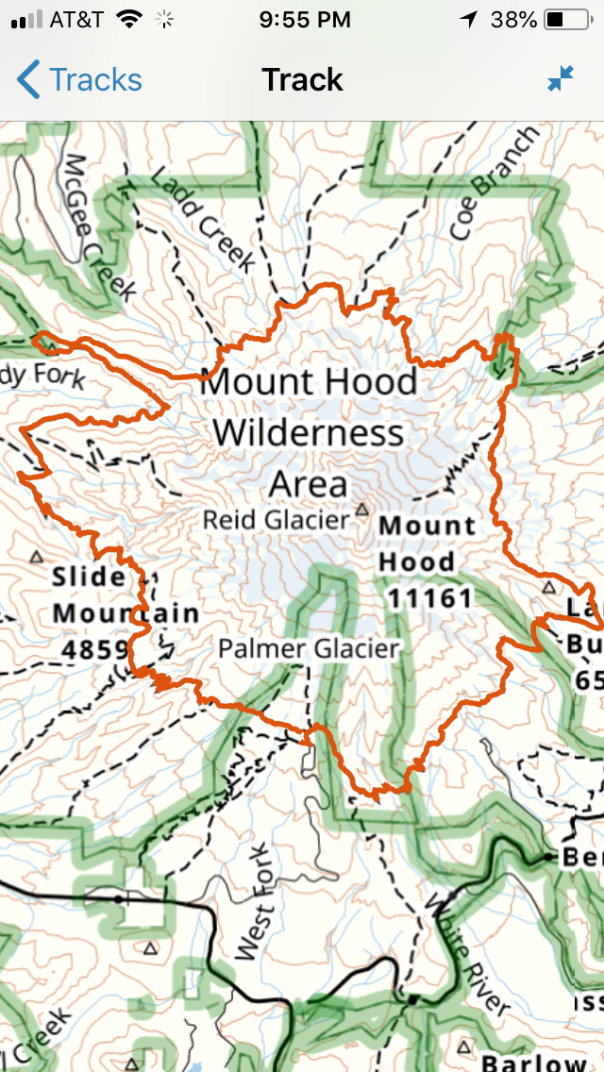
My motivation was multifocal for running the gargantuan 10,000-foot up/down trail in a day. I wanted to test myself with the feat of endurance on this classic trail. I wanted to complete the trifecta of circumnavigations: I’d ridden the 100-mile bike ride around the peak and I’ve done the ski circumnavigation, both in a day. But I also was looking for a deeper understanding of Mount Hood, by connecting all the sections of trails that I’d been on for mountain rescue missions. My unit, Crag Rats, is the mountain rescue team that covers the north side of the mountain (cragrats.org).


So this one-day trail run percolated for a many years in my brain until I realized with a low snowpack and relatively decent running fitness, this was a good year. Realistically I only have a half-dozen friends who a) run longish distances and b) are wont to dig deep into the pain cave. Megan said yes, about 30 seconds after I texted her.
I brought the following in a 10 liter Mountain Hardware backpack: 3 liter water bladder, 1 food bottle with Vitargo and Gatoraid, an Outdoor Research Ferossi jacket, an extra pair of socks (absolutely vital), my iPhone with Gaia GPS app, a Goal Zero battery for my phone, a Steripen UV light water purifier, 6 chlorine dioxide tablets, a tin of Dermatone sunscreen, a roll of tape, Band-aids, and 2000 calories of food, with variety being key (peanut butter/honey sandwich, roasted potatoes which were the bomb, six Hammer gel packs, two Honey Singer Chews packs, a half dozen fig newtons, dried chewy bananas and a couple Mojo bars. I wore a hat, sunglasses, buff, long sleeve Patagonia silkweight shirt, Patagonia ultramarathon shorts, Under Armor tights, Smartwool socks, Outdoor Research gators, and Hoka One One Challenger 2 trail shoes.


We set off from Timberline Lodge at 5:07 a.m. on August 9 at dark and headed counterclockwise. Although one can consider multiple starting points (Cloud Cap and Ramona Falls) and either directions, we chose this route for a variety of reasons, mostly for simplicity of starting and ending at Timberline and splitting up the two major climbs.
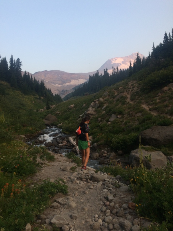
At dawn we ran down into White River, and through Mount Hood Meadows Ski Resort, which was replete with bubbling creeks and beautiful wildflowers. We crossed Clark Creek, climbed up Pea Gravel Ridge, descended into Newton Creek Canyon, and climbed to Gnarl Ridge. From there, we had a long steady climb into the alpine to the highpoint of 7,300 feet. We were greeted with spectacular views of the rarely seen east face of the mountain. Once we hit Cooper Spur, we descended to Cloud Cap Saddle. Status: 15 miles, 4 hours, 9 a.m. On schedule.
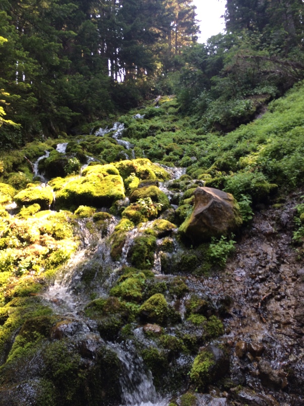
We the dropped into the Eliot Creek, crossed the boulder bridge after a quick fifth-class climbing move and set off on 20 miles of spectacular. Bubbling creeks, wildflowers, springs percolating from the greenery, mossy boulders, and a mostly-smooth wide trail, that was partly shady. We didn’t know it at the time, but our pace slowed significantly due to fatigue and trail conditions. We crossed multiple streams including Coe Branch to end up in Elk Cove, which was absolutely spectacular with wildflowers, glacial brooks, and a large marmot. We took the first of our two five-minute breaks during the 14-hour day: we changed into dry socks after Megan slipped and dunked her foot in a creek. But the black flies were biting so after a quick change we were off again in five minutes.
Running through Cairn Basin, we descended the long, shaded run which turned out to be a bit painful, considering the trail had lots of roots and our legs were shot. Downhill was difficult. On the ridge at the Muddy Fork, the giant rhododendrons showed up, which are typical of the west and south side of the mountain. I was a bit worried about he Muddy Fork and Sandy Rivers: both were swollen with the afternoon heat. But both had log bridges and were easily passible.


By 2 p.m we hit Ramona Falls: picturesque, shaded, and serene. We were exhausted. We sat down for the second time for a solid 5 minutes. But: we still had 10 miles and 3000 feet of elevation to exit. It was, in a word, painful. We walked, but only bit faster than the overnight backpackers. In 5 hours, we stopped twice for water and nothing else. We said a total of about two paragraphs to each other. Although it was painful, it was actually quite beautiful too: we climbed and crossed the gargantuan sandy Zig Zag Canyon and the tiny sandy Sand Canyon.
We arrived, 13 hours and 58 minutes later at Timberline Lodge, a few hours before dark. No, we were not able to stomach a burger and a beer. We were able to change into clean clothes and drink chocolate milk. We had 3.5 falls (me: one). No injuries. No dehydration or heat illness. No rhabdomyolysis, which crossed my mind more than once since two days prior our mountain rescue team was called out for the same.
Much has been said about recovery for this sort of nonsense. I stretched. I slept nine hours. I kitesurfed and I got on my bike for a few light recovery rides in the days following.
My advice:
If you don’t already have this in your list, then don’t do it.
No: we didn’t stop to enjoy the wild flowers but rather saw them in an endorphin-fuled, kaleidoscopic blur.
Yes, we went deep, very deep, into the pain cave.
Yes, we had fun: type 1 for 30 miles and type 2 for the last 10.
No it wasn’t the hardest 24 hours of my life: that was climbing Mount Rainier in a day. But this was close.
Yes there are other circumnavigations: Three Sisters (48 miles), St. Helens (30 miles) and the granddaddy the 93-mile Wonderland around Mount Rainier.
Yes: this is a once in a lifetime. Please don’t ping me if you want me to join you. Well, on second thought, I’ll see how I feel tomorrow.
